# Information Report

This tool opens an information report related to the map elements.&#x20;

Reports display descriptive data pertaining to the pointed elements. They are defined by the JMap administrator.&#x20;

Enable the tool and click on one of the map's elements. If several elements of one or more layers are pointed, several reports will be available in the same window, but only one can be viewed at a time.

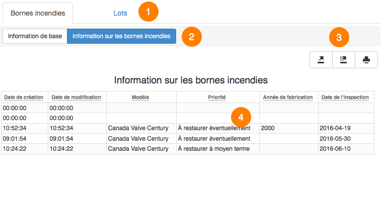
The figure illustrates information reports on two layers:

<figure><img src="/files/ot2hIBH68XQ8hQHXCTtb" alt=""><figcaption></figcaption></figure>

<table data-header-hidden><thead><tr><th width="79"></th><th></th></tr></thead><tbody><tr><td><strong>1</strong></td><td>The top portion of the report displays the names of the layers for which information reports are available at the pointed area.</td></tr><tr><td><strong>2</strong></td><td>Clicking on a given layer allows you to view its list of available reports; the first report is automatically displayed.</td></tr><tr><td><strong>3</strong></td><td>The contents of the displayed report can be exported towards an Excel file or printed.<br>There are also more advanced reports that allow you to export individual attributes to a CSV file.</td></tr><tr><td><strong>4</strong></td><td><p>Information contained in the report is configured by the JMap administrator. </p><p>It can originate from the layer itself or from other data sources associated with the map layer.</p></td></tr></tbody></table>

## Selection information report

This tool allows you to open an information report containing information on all of the selected elements. Select elements and open the report by clicking on the information reports icon.

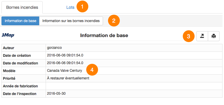
The figure shows an exemple of information report on selection:

<figure><img src="/files/OMMp6EdTSQlbnklBOHKv" alt=""><figcaption></figcaption></figure>

<table data-header-hidden><thead><tr><th width="73"></th><th></th></tr></thead><tbody><tr><td><strong>1</strong></td><td>The names of the layers on which selections have been performed are displayed at the top of the report.</td></tr><tr><td><strong>2</strong></td><td>Clicking on a given layer allows you to view its list of available reports; the first report is automatically displayed.</td></tr><tr><td><strong>3</strong></td><td>The contents of the report displayed can be exported in individual columns to a CSV file, exported in whole to an Excel file, or printed.</td></tr><tr><td><strong>4</strong></td><td>Information contained in the report is configured by the JMap administrator. It can originate from the layer itself or from other data sources associated with the map layer.</td></tr></tbody></table>


---

# Agent Instructions: Querying This Documentation

If you need additional information that is not directly available in this page, you can query the documentation dynamically by asking a question.

Perform an HTTP GET request on the current page URL with the `ask` query parameter:

```
GET https://docs-jmapserver-lima.k2geospatial.com/e/applications/jmap-pro-user-guide/tools/information/information-report.md?ask=<question>
```

The question should be specific, self-contained, and written in natural language.
The response will contain a direct answer to the question and relevant excerpts and sources from the documentation.

Use this mechanism when the answer is not explicitly present in the current page, you need clarification or additional context, or you want to retrieve related documentation sections.