You can select elements on vector layers only. The selected elements can be used to perform various actions, such as running an information report, spatial analysis, editing, etc. Several selection tools are available.
Note that to select layer elements, the layer must be selectable (refer to the section on Layer Settings).
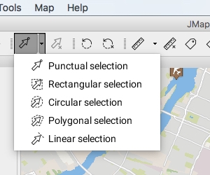
The following figure shows the list of available selection tools.
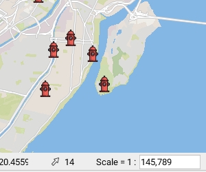
The number of selected elements is always indicated at the bottom of the map.
Select a single element by clicking on it. When several elements are superimposed, only the top one is selected.
Select one or more elements by tracing a rectangle. All elements that are completely or partially included in the rectangle are selected. The rectangle's dimensions are displayed.
Select one or more elements by tracing a circle. All elements that are entirely or partially included in the circle are selected. The circle's radius is displayed.
Select one or more elements by tracing a polygon. All elements that are entirely or partially included in the polygon are selected. The dimensions of the polygon are displayed.
Select one or more elements by tracing a line. All elements on the line's path will be selected.
This option does not work with map points.
Unselect all selected elements on the map.
Using any selection tool, you can press and hold the CTRL key to add or remove elements in an existing selection
Selection tools are compatible with the snap function (refer to the Snap section).
The selection explorer displays the attributes that are bound to the selected elements in the layers. Each layer is represented by a tab.
The interface allows you to access all selected elements at any time, regardless of the layer they belong to.
The selection explorer functions in a similar way to the elements explorer except that it only presents the map's selected elements (refer to the Elements Explorer section).
The figure shows the selection explorer interface:
Enable the tool clicking on and click on an element in the map.
Enable the tool clicking on and trace a rectangle on the map.
Enable the tool clicking on and trace a circle on the map.
Enable the tool clicking on and trace a polygon on the map. Double-click or press the spacebar to complete the polygon.
Enable the tool clicking on and trace a line on the map; double-click or press the spacebar to complete the line.
Enable the tool clicking on .
1
Each layer that contains selected elements is represented by a tab, which indicates the name of the layer and the number of selected objects.
2
A message indicates the total number of selected objects and the number of layers the selection spans.
3
All elements that are listed are selected. If you unselect an element, it disappears from the table.


