# Data Layers

The card for each layer contains information such as the name of the layer, the presence of thematics, the presence of filters on the elements, etc.

To access the available tools, pass the cursor over the card of the layer you are interested in.

<figure><img src="/files/6wT1KVCxC8VTmXcqyKQ3" alt=""><figcaption></figcaption></figure>

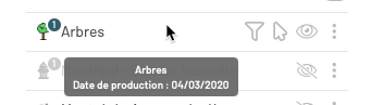
<table data-header-hidden><thead><tr><th width="141" align="center"></th><th></th></tr></thead><tbody><tr><td align="center"><img src="/files/0sS1oLalMuk5amNr8WsO" alt="" data-size="original"></td><td>The icon of the layer reproduces its style, the appearance of the objects of the layer. <br>The icon displays a number when a thematic is configured for the layer. <br>The <a href="/pages/mPisE4CDoIIxkIyZWUNC">Thematics</a> section offers details on this topic.</td></tr><tr><td align="center"><em>Arbres</em></td><td>Layer name.</td></tr><tr><td align="center"><img src="/files/AiOkGlc1knVaAmLlph9T" alt="" data-size="original"></td><td>When metadata (data about data) is configured for the layer, a tooltip displays the layer name and its production date.</td></tr><tr><td align="center"><img src="/files/FpO8hpdYz2TiDQlQkW6F" alt="" data-size="original"></td><td><strong>Filter</strong><br>To display only those elements whose characteristics match the filter parameters. <br>The <a href="/pages/9i9Xk3h4ill7DiJqFJHq">Filter Elements on the Map</a> section provides details on setting up and managing filters.</td></tr><tr><td align="center"><img src="/files/1OSVYlPjddjL7o6DFzvO" alt="" data-size="original"></td><td><strong>Select</strong><br>This tool makes the elements of the layer selectable for editing, producing information reports, etc. <br>The <a href="/pages/RBVYw8fJvEn1JTG34rTG">Making Layer Elements Selectable</a> section provides details on this topic.</td></tr><tr><td align="center"><img src="/files/uqZqtJ0JLokNdFsxMl6z" alt="" data-size="original"> / <img src="/files/d35uYhXGv9oge38oL43C" alt="" data-size="original"></td><td><strong>Display</strong><br>To activate or deactivate the display of the layer in the map. <br>The <a href="/pages/02EFpiWanwxoZ1JpIu8U">Displaying Layers</a> section provides details on this feature.</td></tr><tr><td align="center"><img src="/files/uUomlc7oEO7LH09OQn3Y" alt="" data-size="original"></td><td><p><strong>Menu</strong><br>Contains other functions: </p><p><strong>More information</strong>: the <a href="/pages/F0nnhcl0JO8p37B81ThW">Information</a> section provides details on this feature. </p><p><strong>Thematic management</strong>: the <a href="/pages/mPisE4CDoIIxkIyZWUNC#thematics-management">Thematics management</a> section provides details on this feature. </p><p><strong>Zoom to layer extent</strong>: the <a href="/pages/p9kt5oSYfV1ceOhhe0S8">Geographic Extent of the Layer</a> section provides details on this feature. </p><p><strong>Filter elements on the map</strong>: The <a href="/pages/9i9Xk3h4ill7DiJqFJHq">Filter Elements on the Map</a> section provides details on this feature.</p></td></tr></tbody></table>


---

# Agent Instructions: Querying This Documentation

If you need additional information that is not directly available in this page, you can query the documentation dynamically by asking a question.

Perform an HTTP GET request on the current page URL with the `ask` query parameter:

```
GET https://docs-jmapserver-lima.k2geospatial.com/e/applications/jmap-ng-user-guide/the-data/data-layers.md?ask=<question>
```

The question should be specific, self-contained, and written in natural language.
The response will contain a direct answer to the question and relevant excerpts and sources from the documentation.

Use this mechanism when the answer is not explicitly present in the current page, you need clarification or additional context, or you want to retrieve related documentation sections.