JMap Server Lima
English
English
  • Welcome to JMap Server Lima
  • Administrator
    • JMap Server Administrator Manual
      • Introduction
        • Quick Start Guide
        • User Interface
          • Old User Interface
      • Resources: Databases
        • Creating Databases
        • Configuring Databases
          • Database Permissions
        • Managing Databases
        • JMap Server System Database
      • Resources: JMap Server to JMap Server Connections
        • Creating Connections to JMap Server
        • Configuring JMap Server to JMap Server Connections
          • Permissions for the Remote Connection
        • Managing Connections
      • Resources: Spatial Data
        • Basic Concepts
        • Creating Spatial Data Sources
        • Configuring Spatial Data Sources
          • Spatial Data Source Permissions
          • External Attributes
          • Metadata
          • Sharing Spatial Data Sources
        • Managing Spatial Data Sources
        • Vector Data Sources
          • JMap ADF - E00 Arc - Info reader
          • JMap CSV reader
          • JMap DGN V7 - V8 File reader
          • JMap DWG - DXF reader
          • JMap EDIGEO reader
          • JMap File geodatabase reader
          • JMap GeoJSON reader
          • JMap GML reader
          • JMap GPX reader
          • JMap IFC reader
          • JMap KML reader
          • JMap MID - MIF reader
          • JMap Photo reader
          • JMap SHP reader
          • JMap TAB reader
          • Annotations in a database
          • ArcGIS REST
          • ArcSDE geodatabase
          • Coordinates in a database
          • Enterprise geodatabase
          • JMap Server
          • JMap Spatial Table
          • MongoDB
          • MySQL Spatial
          • OGC API Features
          • Oracle Spatial Locator
          • Personal geodatabase
          • PostGIS
          • SQL Server Spatial
          • WFS Server
          • WKB or WKT in a database
        • Raster Data Sources
          • ECW - JPG2000
          • GDAL - Geospatial Data Abstraction Library
          • ArcGIS REST
          • JMap Server
          • OpenStreetMap
          • WMS server
          • WMTS Server
      • Resources: Metadata templates
      • Resources: Projects
        • Creating Projects
          • Multilingual Projects
          • Vector tiles in JMap
        • Configuring Projects
          • Project Permissions
          • Managing Layers
            • Organizing Layers
          • Attribute Queries
            • Attribute Query Forms
          • Image Producer
          • JMap Extensions Compatible with JMap NG or JMap Survey
        • Sharing the Project
        • Managing Projects
      • Resources: Style Templates
        • Creating Style Templates
        • Managing Style Templates
      • Resources: Personal Layers
      • Resources: Layers
        • Creating Layers
        • Configuring Layers
          • Layer Permissions
          • General Settings
          • Dynamic Filters
          • Style
          • Thematics
          • Labels
          • Mouseover
          • Information Reports
          • Forms
            • Configuring Forms
            • Creating Forms
              • Layer Attributes Forms
              • Database Forms
          • JMap Extensions
        • Sharing Layers
      • JMap Server Applications
        • Deployment: Classical JMap applications
          • JMap Pro Applications
          • JMap Web Applications
            • Using a GeoWebCache Server
          • WFS and WMS Services
          • Managing Deployed Applications
          • Downloading Services
        • New generation JMap applications
      • Tools
        • SQL Console
        • Import / Export
          • User Data
        • Scheduler
        • Messaging
        • Debugging tools
      • JMap Server Extensions
        • Installed Extensions
        • Marketplace
      • JMap Server
        • JMap Server Status
        • Sessions
        • Security
          • Users and Groups
            • User Managers
              • JMap DB user manager
              • Composite user manager
              • Active Directory user manager
              • JMap LDAP user manager
              • OpenID Connect (OIDC) user manager
              • SAML2 user manager
            • Single Sign-On for JMap Pro
          • Managing Permissions
          • Using HTTPS with JMap
        • Log Files
        • Usage Statistics
        • JMap Server Settings
    • Technical Specifications
    • Installation Guide
    • Installing and Starting JMap Server (with installer)
    • Installing and Starting JMap Server (in a Docker container)
    • Migration Guide to JMap Server Lima
  • Applications
    • JMap Server Applications
    • JMap Pro User Guide
      • Introduction
        • User Interface
        • Navigating on the Map
        • Map Management
        • Map Settings
      • Map Layers
        • Layer Management
        • Elements Explorer
        • Thematic Maps
        • Layer Metadata
        • Layer Settings
          • General
          • Style
          • Thematics
          • Labeling
          • Mouseover
          • Filters
          • Advanced
        • Editable Layers
          • Editing Data
          • Personal Layers
      • Tools
        • Labeling
        • Interactive Selection
        • Information
          • Information Report
          • Geometry Information
          • Mouseover
        • Snap
        • Measurement
        • Search Tools
          • Attribute Queries
          • Spatial Queries
        • Collaboration Tools
          • Map Contexts
          • Sharing Maps
          • Printing Maps
      • Application Settings
      • Keyboard and Mouse Shortcuts
    • JMap NG User Guide
      • Introduction
        • Connecting to JMap NG
        • User Interface
        • Navigating on the Map
        • Profile and User Settings
      • The Data
        • The Layers Panel
        • Data Layers
          • Displaying Layers
          • Thematics
          • Layer Information
          • Geographic Extent of the Layer
          • Filter Elements on the Map
          • Making Layer Elements Selectable
      • I Wish to...
        • Display Element Information
          • Tooltips
          • Information Reports
        • Perform Searches
        • Select Elements on the Map
        • Measure Distances and Surfaces
        • Add Annotations to the Map
        • Edit Data
        • Create and Manage Customized Maps
        • Export / Print a Map
    • JMap Survey User Guide
      • Introduction
        • Working With an iOS Device
        • Working With an Android Device
        • Logging In
        • User Interface
      • The Data
      • I Wish to...
        • Access Information Associated With an Object
        • Perform Searches
        • Create Objects
        • Modify Objects
        • Work in Offline Mode
        • Synchronize Data with JMap Server
        • Log Out
    • JMap Web
      • JMap Web User Guide
  • Extensions
    • Edition
      • User Interface
      • Basic Concepts
      • I Wish to...
        • Edit Layers Geometries
          • Edition Tools
          • Selecting Elements
          • Node and Polygon Operations
          • Vertical Position and Element Duplication
          • WKT Geometries
        • Perform Spatial Operations
          • Geoprocessing
          • Spatial Tools
    • Export
    • Import
      • Importation Procedure
        • Importing MIF Files
        • Importing SHP Files
        • Importing CSV Files
        • Importing NMEA Data
        • Importing Data From WMS
    • Documents
      • Configuring JMap Documents
        • Selecting Data Sources to Associate Documents with
        • Configuring Document Depots
        • Managing repositories
        • Making Documents available in apps
      • Documents for JMap Pro
        • Graphical Interface
        • Associating Documents with Map Elements
        • Searching for Documents
        • Displaying the List of Documents Associated with Elements
      • Documents for JMap NG
        • Graphical Interface
        • Searching for Documents
        • Showing Selected Documents
      • Documents for JMap Survey
    • Tracking
      • Administrator
      • User
    • JMap NG Configuration
      • Configuration
  • Developer
    • JMap Server REST API
    • JMap Admin REST API
    • JMap Pro / Server API
    • JMap Web API
    • JMap Server SDK
    • JMap NG Developer Manual
      • Startup Options
      • Extensions
      • Examples
        • Start the JMap NG Core library
        • Start the JMap NG App
        • Add a JMap NG App extension
        • Toggle a JMap layer visibility
        • Add a layer to display custom data from GeoJSON file
        • Locate and select features by attribute query
        • Add an event on move end
        • Add attributions on the map
        • Locate and select feature by id
        • Locate and select feature(s) by location
        • Custom mouseover on a layer
        • Create a custom form in a div
      • Changelog
  • Knowledge Base
    • Knowledge Base
Propulsé par GitBook

K2 Geospatial 2024

Sur cette page
  • Adding a document to a depot
  • File depot
  • Hyperlink depot
  • Associating a document with map elements
Exporter en PDF
  1. Extensions
  2. Documents
  3. Documents for JMap Pro

Associating Documents with Map Elements

PrécédentGraphical InterfaceSuivantSearching for Documents

Dernière mise à jour il y a 7 mois

This feature allows you to create associations between map layer elements and documents contained in a depot. You can also use it to add a document to an existing depot and associate it with map elements afterwards.

You must have the required permissions to use this feature.

Adding a document to a depot

To add a document, which can later be associated with map elements, follow these steps:

  1. Select one or more map elements in one or more layers.

  2. Click on Add Associations to open the Add documents window.

    1

    Each tab corresponds to a layer that contains the map elements included in the selection.

    2

    3

    Information on the number of map elements selected and the number of layers they belong to.

    4

    These tools allow you to sort map elements, centre a specific element in the map, invert the selection, unselect elements, and export selected elements to an Excel spreadsheet. These tools are similar to those of the elements explorer in JMap Pro.

    5

    Attributes of the selected elements.

    If one of the layers whose elements you selected is not configured in order for elements to be associated with it, an error message displays, and you must unselect the layer elements in order to continue.

  3. Click on Next to select a depot in which you will store the document to be added or to choose the document to associate with map elements. Each depot can have a description.

File depot

  1. If you are adding documents to a file depot, click on Next to select the appropriate file type.

    You cannot associate map elements with local files directly. You must first add the local files to a depot, then associate them with the map elements.

  2. Select Local files to add a new document to the depot from your computer.

  3. Click on Next to select the local file.

  4. Click on Next to access information on the completeness of the metadata.

  5. Double-click on the name of the file. This will open the interface to enter the metadata. The metadata is configured by the JMap administrator for each document depot.

    1

    You can change the file name. The file name is a default metadata element of document depots in JMap Documents.

    2

    You can add a description to the file. The description is a default metadata element of document depots in JMap Documents.

    3

    This metadata is specific to the selected depot.

  6. Click on OK to return to the file’s metadata interface. The Metadata completed check box is selected, and you can proceed to the next step.

  7. Select the destination of the document in the depot. Depending on the depot’s configuration, you can browse through the directory of the depot and create a new folder to host the local file.

  8. Click on Finish to copy the local document in the selected depot. The Add documents window closes.

Hyperlink depot

To associate map elements with documents hosted in a website, follow these steps:

  1. Click on Next to add the URL containing the document(s). The URL must be in the following format: http://…

  2. Click on Finish to add the document.

The website referenced by the URL is associated with the selected elements.

Associating a document with map elements

A document that is added to a file depot will not be automatically associated with the selected map elements. To associate it, you must go through the Add documents wizard once again while keeping the map elements selected.

  1. Select Depot files to associate a document with your selection.

  2. Click on Next to choose the document(s) you wish associate with your selected elements.

  3. The Search documents interface allows you to select a form among those that have been configured for the depot. You can also determine if the document you are looking for is associated with map elements. Lastly, you can enter keywords for your search. The search results are listed in a table that provides a few details on each document retrieved.

  4. Check the boxes of the documents you are interested in to select them.

  5. Click on OK to return to the Search result window. The documents selected using both methods are listed in a table. You can select and unselect documents as needed.

This button allows you to access the layers directly.
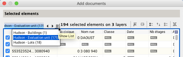
JMap Pro Documents supports connections to (including SharePoint) and . The steps that follow will depend on the type of depot you select.

Click on Add Associations to open the Add documents window.

Click on Depot explorer to select the files by browsing through the depot’s directories.

Click on Search documents to perform a search using keywords.

Click on Finish to associate the selected documents with the selected map elements. The interface automatically closes. A table similar to the elements explorer is displayed. The section provides details on the table’s components.

Searching for documents
file depots
hyperlinks